Canoeing the Gasconade River in Waynesville, Missouri
Category
Natural Landmark
Typical Duration
20 minutes
Difficulty
Moderate
About This Landmark
Canoeing the Gasconade River in Waynesville, Missouri
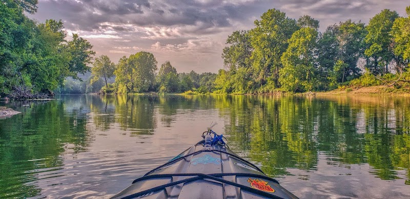
Canoeing the Gasconade River offers an unforgettable journey through the heart of Waynesville, Missouri, combining scenic landscapes with rich history. Known as one of the most winding rivers in the nation, the Gasconade provides adventurers with tranquil waters, diverse wildlife, and stunning Ozark backdrops. With access points conveniently located near Waynesville, it’s an activity that highlights the natural beauty and unique charm of the region. Whether you’re a first-time paddler or an experienced canoeist, the Gasconade River showcases the unmistakable allure of Missouri’s outdoor offerings.
Adventure Guide To Canoeing the Gasconade River
-
Roubidoux Creek to Schlicht Springs
- Location: Begin at the Roubidoux Creek confluence in Waynesville and paddle downstream toward Schlicht Springs.
- What Makes It Special: This stretch is ideal for beginners due to its calm currents and shorter distance. You'll pass under the historic Roubidoux Bridge and see limestone bluffs that define the local landscape.
- Key Features: Opportunity for wildlife sightings such as bald eagles and river otters. Public access areas allow for breaks to enjoy the scenery.
-
Bell Bluff to Boiling Spring Campground
- Location: Put in near Bell Bluff, approximately 20 minutes from Waynesville, and end at Boiling Spring Campground.
- What Makes It Special: This portion offers intermediate paddlers a chance to tackle moderate currents while enjoying panoramic views of the Ozark foothills.
- Key Features: Boiling Spring itself is a geological wonder, producing consistently clear, cold water. Nearby picnic spots make it a great day trip.
-
Richland Access Point to Waynesville City Park
- Location: Begin in Richland and paddle back to the city park in Waynesville.
- What Makes It Special: Perfect for an in-depth look at the area’s flora and fauna. The route is long but manageable, providing uninterrupted views of unspoiled nature.
- Key Features: Abundant fishing opportunities along the way, with catfish and bass dominating the waters.
Local Insights
The Gasconade River is Missouri’s longest river entirely within the state. Its name originates from French settlers, referencing the river’s winding, “boasting” characteristics. Historically, the river was a critical resource for Native American tribes and early settlers traveling through the Ozarks.
Visitor Tips
- Best Times: Spring and early summer offer the best water levels; fall provides crisp temperatures and vibrant foliage.
- What To Bring: Sunscreen, water shoes, life jackets, and waterproof bags for personal belongings.
- Driving Directions: From the Ozark Mountains, take I-44 East to Waynesville, approximately a 1-hour drive.
Photo Gallery
Canoeing the Gasconade River in Waynesville, Missouri
- Best Times: Spring and Fall for cooler temperatures and amazing lighting.
- What to Bring: Water, sunscreen, and a camera!
Reviews
Location
Canoeing the Gasconade River in Waynesville, Missouri in Waynesville
Coordinates: 38.0754, -91.8893
Ratings
Overall
Weather Considerations
Temperature
Varies by season, check forecast
Precipitation
Best to visit in dry conditions
Experience Level
Experience Needed: This natural landmark is recommended for those with some outdoor experience. Good for regular hikers.